Property Record
Ladysmith Rd, Ruther Glen, VA 22546
NEARBY LISTINGS FOR SALE OR LEASE
Property Detail
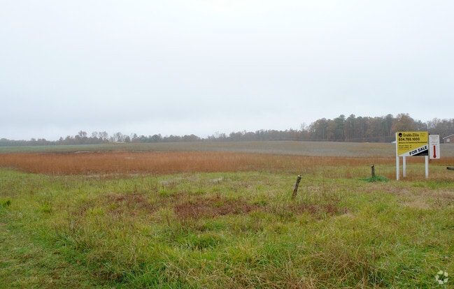
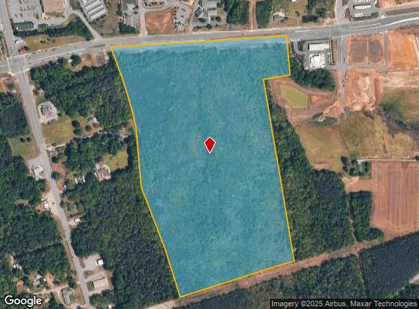
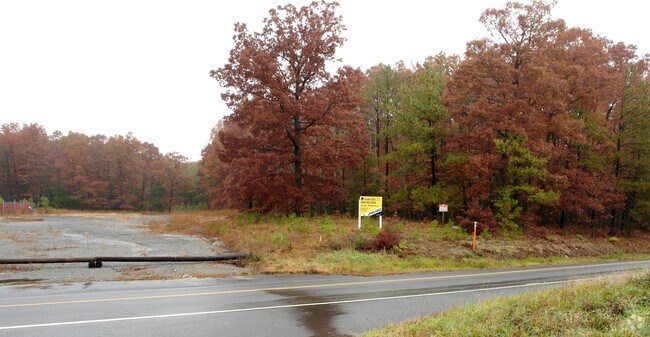
Ladysmith Rd
52-A-122A
Ladysmith
Agriculturalland
LADYSMITH PARCEL B
X
Caroline
51033C0200D
Virginia
2025
35.87 AC
2025
Caroline County
030503
Washington, DC
DEMOGRAPHICS near Ladysmith Rd
1 Mile
3 Mile
5 Mile
2024 Total Population
1,475
9,872
14,339
2029 Population
1,614
10,723
15,530
Pop Growth 2024-2029
+ 9.42%
+ 8.62%
+ 8.31%
Average Age
35
38
39
2024 Total Households
521
3,611
5,261
HH Growth 2024-2029
+ 9.60%
+ 8.78%
+ 8.44%
Median Household Inc
$67,159
$77,825
$80,841
Avg Household Size
2.70
2.70
2.70
2024 Avg HH Vehicles
3.00
3.00
3.00
Median Home Value
$240,136
$250,402
$256,495
Median Year Built
2003
2000
1996
Nearby Places
Map Layers
Map Styles
 Street
 Aerial
- Restaurants
- Banks
- Shops
- Fitness
- Groceries
Nearby Properties
Address
Land Use
TOTAL SIZE
Lot Size
Zoning
Address
Land Use
TOTAL SIZE
Lot Size
Zoning
92,700 SF
22.06 AC
PRD
Address
Land Use
TOTAL SIZE
Lot Size
Zoning
43,440 SF
16.92 AC
RP
Address
Land Use
TOTAL SIZE
Lot Size
Zoning
48,248 SF
16.90 AC
RP
Address
Land Use
TOTAL SIZE
Lot Size
Zoning
40,744 SF
10 AC
PMUD
Address
Land Use
TOTAL SIZE
Lot Size
Zoning
4,484 SF
97.25 AC
M1
Address
Land Use
TOTAL SIZE
Lot Size
Zoning
54,086 SF
7.17 AC
B1
Address
Land Use
TOTAL SIZE
Lot Size
Zoning
10,200 SF
19.91 AC
M1
Address
Land Use
TOTAL SIZE
Lot Size
Zoning
22.43 AC
PSC
Address
Land Use
TOTAL SIZE
Lot Size
Zoning
3,536 SF
9.16 AC
R2
Address
Land Use
TOTAL SIZE
Lot Size
Zoning
60,880 SF
44.46 AC
M1
Address
Land Use
TOTAL SIZE
Lot Size
Zoning
14.07 AC
PSC
Address
Land Use
TOTAL SIZE
Lot Size
Zoning
728 SF
4.41 AC
B1
Address
Land Use
TOTAL SIZE
Lot Size
Zoning
26,596 SF
2.12 AC
B1
Address
Land Use
TOTAL SIZE
Lot Size
Zoning
26,520 SF
140.38 AC
M1
Address
Land Use
TOTAL SIZE
Lot Size
Zoning
19,164 SF
3.58 AC
M1
Address
Land Use
TOTAL SIZE
Lot Size
Zoning
2.39 AC
PSC
Address
Land Use
TOTAL SIZE
Lot Size
Zoning
6,128 SF
2.57 AC
B1
Address
Land Use
TOTAL SIZE
Lot Size
Zoning
37,660 SF
14.01 AC
M1
Address
Land Use
TOTAL SIZE
Lot Size
Zoning
10,254 SF
7 AC
B1
Address
Land Use
TOTAL SIZE
Lot Size
Zoning
99 AC
PMUD
Address
Land Use
TOTAL SIZE
Lot Size
Zoning
32,252 SF
25.24 AC
M1
Address
Land Use
TOTAL SIZE
Lot Size
Zoning
2,636 SF
2.16 AC
M1B1
Address
Land Use
TOTAL SIZE
Lot Size
Zoning
12,638 SF
22.73 AC
RP
Address
Land Use
TOTAL SIZE
Lot Size
Zoning
18,190 SF
7.51 AC
RP
Address
Land Use
TOTAL SIZE
Lot Size
Zoning
65.86 AC
RP
Address
Land Use
TOTAL SIZE
Lot Size
Zoning
4,324 SF
2.48 AC
B1
Address
Land Use
TOTAL SIZE
Lot Size
Zoning
3,569 SF
4.29 AC
B1
Address
Land Use
TOTAL SIZE
Lot Size
Zoning
164.61 AC
M1B1
Address
Land Use
TOTAL SIZE
Lot Size
Zoning
9,222 SF
1.05 AC
B1
The World's #1 Commercial Real Estate Marketplace
Connect with us
© 2026 CoStar Group
The information above has been obtained from sources believed reliable. While we do not doubt its accuracy we have not verified it and make no guarantee, warranty or representation about it. It is your responsibility to independently confirm its accuracy and completeness. Any projections, opinions, assumptions, or estimates used are for example only and do not represent the current or future performance of the property. The value of this transaction to you depends on tax and other factors which should be evaluated by your tax, financial, and legal advisors. You and your advisors should conduct a careful, independent investigation of the property to determine to your satisfaction the suitability of the property for your needs.